Sommaire des étapes :
- Etape 01 : Bergambacht – Moordrecht: 29,301kms
- Etape 02 : Moordrecht – Wassenaar: 52,3kms
- Etape 03 : Wassenaar- Bloemendal: 56,469kms
- Etape 04 : Bloemendal – Caastricum: 34,634kms
- Etape 05 : Caastricum – Groet: 39,265kms
- Etape 06A : Groet – Den Helder : 33,343kms
- Etape 06B : Texel – Oudeschild : 7kms
- Etape 07 : Texel : Oudeschild – Den Hoorn : 46,198kms
- Etape 08A : Texel : Den Hoorn – Embarcadère : 3,972kms
- Etape 08B : Den Helder – Westerland : 31,452kms
- Etape 09 : Westerland – Harlingen : 48,523kms
- Etape 10 : Harlingen – Sint Annaparochie : 40,2kms
- Etape 11 : Sint Annaparochie – Bartlehiem: 45,996kms
- Etape 12 : Bartlehiem – Sneek : 40,963kms
- Etape 13 : Sneek – Molkwarum: 35,676kms
- Etape 14A : Molkwarum – Stavoren : 4,992kms
- Etape 14B : Enkhuizen- Berkhout: 27,09kms
- Etape 15 : Berkhout – Amsterdam : 43,1kms
- Etape 16 : Amsterdam – Utrecht : 48,326kms
- Etape 17 : Utrecht – Haastrect : 49,289kms
- Etape 18 : Haastrect – Bergambacht : 50,671kms
Détail des étapes :
Camping du départ :
Bergambacht:
« Camping de Nes (3 trekkershutten)
Details: Lekdijk West 105, 2861 EV Bergambacht, Zuid-Holland, Netherlands, Tel. 0182-352072,
GPS coördinaten: 51° 54′ 59.0 » N 4° 45′ 7.6 » E (51.91640 / 4.75210 )
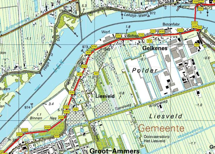
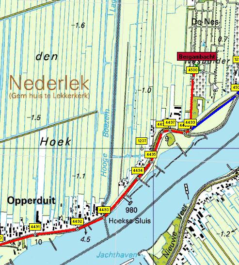
Vue générale de l’étape :

Détail de l’étape :


Détail de l’étape


Camping fin étape :
Duinhorst
http://www.duinhorst.nl/
E-mail: info@duinhorst.nl
Telefoon: 070-3242270
adres: Buurtweg 135, 2244BH Wassenaar.
GPS coördinaten: 52° 6′ 39.0 » N 4° 20′ 36.5 » E (52.11083 / 4.34347 )


Camping fin étape :
Kennemer Duincamping de Lakens
E-mail: delakens@kennemerduincampings.nl
Telefoon: 023-5411570
adres: Zeeweg 60, 2051EC Bloemendaal aan Zee.
GPS coördinaten: 52° 24′ 26.6 » N 4° 33′ 21.6 » E (52.40740 / 4.55600 )


Camping arrivée
CASTRICUM : Kennemer Duincamping Geversduin
Beverwijkerstraatweg 205, 1901NH CASTRICUM, Noord-Holland, Netherlands, Tel. 0900-3846226, http://www.kennemerduincampings.nl
GPS coördinaten: 52° 31′ 56.5 » N 4° 38′ 44.8 » E (52.53237 / 4.64578 )
Vue globale de l’étape :

Détail de l’étape :


Camping arrivée :
De Paardenhemel
E-mail: depaardenhemel@gmail.com
Telefoon: 072-5091789
adres: Hargerzeeweg 20, 1873HK Groet.
GPS coördinaten: 52° 43′ 14.9 » N 4° 39′ 40.3 » E (52.72080 / 4.66120 )
Vue globale de l’étape:


Détail de l’étape:


Camping à Den Helder (au cas où) car la traversée est prévue en fin de journée
Den Helder : De Donkere Duinen
Details: Jan Verfailleweg 616, 1783 BW Den Helder, Noord-Holland, Netherlands, Tel. 0223-614731,
http://www.donkereduinen.com
GPS coördinaten: 52° 56′ 11.0 » N 4° 44′ 2.8 » E (52.93640 / 4.73410 )
Informations concernant la traversée
Traversée Ferry : NL Den Helder NL Texel (Texel)durée 30mn / 14-16 fois par jour / Info / Teso
Teso sails according to a fixed timetable, operating an extra ferry on busy days.
The normal timetable is as follows:
* The ferry from Den Helder leaves every hour on the half hour from 6.30 a.m. to 9.30 p.m.
* The ferry from Texel leaves every hour on the hour from 6.00 a.m. to 9.00 p.m.
* On Sundays and public holidays, the first sailing is one or two hours later, depending on the season.
Sundays and Holidays
* From 1 April to 1 October, on Sundays and Holidays, the service starts at 7.00 am from Texel and at 7.30 am from Den Helder.
You have selected: 2x Bicycles: incl. rider (age 12-65),
1x passengers without bicycle (4 yrs +)
2x 1 Return Bicycles and mopeds incl. rider €10.00
1x 1 Return foot passenger €2.50
Fin de l’étape précédente : arrivée au camping sur Texel:

Vues détaillées :


Détail concernant le camping
De Vrije Vogel , boerderijcamping
http://www.vrijevogeltexel.nl/
E-mail: info@vrijevogeltexel.nl
Telefoon: 0222-314509
adres: Laagwaalderweg 21, 1792CE Oudeschild – Texel.
GPS coördinaten: 53° 3′ 15.0 » N 4° 50′ 27.4 » E (53.05416 / 4.84094 )
Vue générale de l’étape : tour de l’île

Vue détaillée de l’étape:
Route vers le Nord de l’île :


Route vers le Sud :


Camping sélectionné:
Texelcamping Loodsmansduin
http://www.texelcampings.nl/index.php?option=com_content&task=view&id=74&Itemid=4
E-mail: info@texelcampings.nl
Telefoon: 0222-317208
adres: Rommelpot 19, 1797RN Den Hoorn – Texel.
GPS coördinaten: 53° 1′ 16.4 » N 4° 44′ 25.8 » E (53.02121 / 4.74051 )
Vue générale de l’étape :

Vue détailléede l’étape :

Vue détaillée de l’étape :

Vues détaillées de l’étape :


Camping sélectionné :
De Torenhoeve
E-mail: torenhoeve@zonnet.nl
Telefoon: 0227-593938
adres: Dam 7, 1778KV Westerland.
GPS coördinaten: 52° 53′ 40.5 » N 4° 54′ 51.3 » E (52.89459 / 4.91424 )
Vue générale de l’étape :


Vue détaillée de l’étape :


Camping sélectionné :
De Zeehoeve
http://www.zeehoeve.nl/?categorie=home&taal=nl
E-mail: info@zeehoeve.nl
Telefoon: 0517-413465
adres: Westerzeedijk 4, 8862PK Harlingen.
GPS coördinaten: 53° 9′ 45.8 » N 5° 25′ 2.4 » E (53.16273 / 5.41733 )
Vue générale de l’étape :

Vue détaillée de l’étape :


Camping sélectionné :
De Noordster
E-mail: noordster@noordster.nl
Telefoon: 0518-403040
adres: Nieuwe Bildtdijk 289, 9076PP Sint Annaparochie.
GPS coördinaten: 53° 18′ 27.7 » N 5° 39′ 23.0 » E (53.30770 / 5.65640 )
Vue générale de l’étape :

Détails de l’étape :


Camping sélectionné :
Bartlehiem
http://www.campingbartlehiem.nl/
E-mail: info@campingbartlehiem.nl
Telefoon: 0519-332580
adres: Bartlehiem 13, 9091BJ Bartlehiem.
GPS coördinaten: 53° 16′ 21.3 » N 5° 50′ 18.3 » E (53.27257 / 5.83843 )
Vue générale de l’étape :


Détails de l’étape :


Camping sélectionné :
Synneveer , minicamping (CAMP3)
http://www.campingsynneveer.nl/
E-mail: campingsynneveer@live.nl
Telefoon: 0515–422984
adres: Lemmerweg 86, 8607JK Sneek.
GPS coördinaten: 53° 0′ 27.4 » N 5° 39′ 10.8 » E (53.00760 / 5.65300 )
Vue générale de l’étape :

Détails de l’étape :


Camping sélectionné :
‘t Seléantsje
http://www.camping-seleantsje.nl/
E-mail: info@surfcamping.nl
Telefoon: 0514-681395
adres: ‘t Séleantjse 2, 8722HE Molkwerum.
GPS coördinaten: 52° 54′ 12.3 » N 5° 23’ 46.5 » E (52.90341 / 5.39626 )
Vue générale de l’étape :

Détails de l’étape :

Détail de la traversée en ferry :
In the 80 minutes it takes to cross the IJsselmeer , you can enjoy the view from the sun deck, the upper or the lower (non smoking) salons or the cozy bar in the front of the boat.
Departure from Stavoren (near railway station)
Month: Date: Time:
May until Sept. 30 daily 10.05 14.05 18.05
Arrival Enkhuizen 11.40 15.30 19.30
http://www.veerboot.info/UK/index.php
Vue générale de l’étape :

Détails de l’étape :


Camping sélectionné :
‘t Venhop
E-mail: info@venhop.nl
Telefoon: 0229-551371
adres: De Hulk 6A, 1647DP Berkhout.
GPS coördinaten: 52° 37′ 52.3 » N 5° 0′ 33.1 » E (52.63120 / 5.00920 )
Vue générale de l’étape :


Détails de l’étape :


Camping sélectionné :
Camping Zeeburg
E-mail: info@campingzeeburg.nl
Telefoon: 020-6944430
adres: Zuider IJdijk 20, 1095KN Amsterdam.
GPS coördinaten: 52° 21′ 53.6 » N 4° 57′ 39.4 » E (52.36490 / 4.96095 )
Vue générale de l’étape :


Détails de l’étape :


Camping sélectionné :
Fort aan de Klop
http://www.fortaandeklop.com/camping_utrecht_fort_aan_de_klop.htm
E-mail: info@fortaandeklop.com
Telefoon: 030-2660555
adres: 1e Polderweg 4, 3563MC Utrecht.
GPS coördinaten: 52° 7′ 13.1 » N 5° 5′ 16.8 » E (52.12031 / 5.08801 )
Vue générale de l’étape :

Détails de l’étape :


Camping sélectionné :
Streefland
http://www.campingstreefland.nl/
E-mail: info@campingstreefland.nl
Telefoon: 0182-502297
adres: Provincialeweg West 27, 2851EJ Haastrecht.
GPS coördinaten: 52° 0′ 3.7 » N 4° 45′ 20.4 » E (52.00103 / 4.75566 )
Détails de l’étape :


Camping sélectionné :
Le même qu’au départ
Bergambacht:
« Camping de Nes (3 trekkershutten)
Details: Lekdijk West 105, 2861 EV Bergambacht, Zuid-Holland, Netherlands, Tel. 0182-352072,
GPS coördinaten: 51° 54′ 59.0 » N 4° 45′ 7.6 » E (51.91640 / 4.75210 )
Total de la boucle : 768kms


